Wednesday, 27 December 2017

Wednesday – Oct 4, 2017 Phuyupatamarca to Machu Picchu
Inca Trail Day 4
We both got up a bit before the wake-up call at 7am. I went for a visit to the toilet tent and Russell got all dressed and was outside the tent and ready to go when I got back, before we even got our tea and bowls of warm water. It had stopped raining, but fog was hovering over the campsite. This little fellow was outside the tent.
I washed up, dressed, and packed our duffle bags. It was a bit easier organizing the stuff in the tent for the porters to pack up today. Last night was the last night in the tent, so I didn’t need to worry about properly separating and identifying whose sleeping bag and pillow was whose. We both really enjoyed our tenting experience on the Inca Trail.  It was very cozy. It was hard to believe the tenting aspect was over, the three nights just flew by.
It dawned on me when I got out of the tent that we had just left our poles outside last night, and they weren’t there this morning. Not to worry, the porters had picked them up and put them in the dining tent because it was raining, which was much appreciated.
Russell must have gone off to the toilet block because he wasn’t in the dining tent when I arrived.  I made a comment to Mike and Sue-Anne about how slippery the rocks were, and they told me in confidence that Russell took a tumble on the rocks before dinner last night, while I was in the tent, and he had made them swear not to tell me. They both seemed to think it was a pretty nasty fall.
We had pancakes for breakfast, which were delicious.  Sue-Anne is a celiac and Peter had even made gluten free pancakes for her. I asked if they had any Canadian maple syrup to put on them, and Carlos hailed Peter who produced some honey. I don’t think they had ever heard about Canadian maple syrup. Carlos seemed a bit suspicious about why anyone would want to eat tree sap in the first place. We also had some lovely wild berry jam, which was delicious.
In deciding the on the tips yesterday, it was agreed to give the cook, the assistant cook, and the chief porter a larger tip than the rest of the porters. At breakfast, Carlos told us that we didn’t have an assistant cook, so we all agreed to give the extra we had set aside for the assistant cook to the toilet tent attendant.  
After breakfast we all gathered to say our thank you ’s and good-byes to the porters.  We would only be seeing the lunch crew again. The rest of the porters would be running down to the river to wash all the tents, sleeping bags, etc.
At the gathering, Carlos asked if anyone would like to say anything, and Mike and I said we would.  Mike said thank-you ’s on behalf of all of us, distributed the tips, and then Carlos said a few words and we started taking photos.  I was a bit disappointed Carlos didn’t recognize that I wanted to say something, but what I didn’t know – because it took me so long to get ready for dinner last night and missed the whole good-byes / tips discussion – is that the others had all agreed that Mike would make a speech on behalf of the group. Carlos was ever mindful of the time! I agree that was the practical approach, but I would have liked to express my deeply felt appreciation for all that the porters did for us myself. I told Carlos along the way later that day what I had wanted to say, and he said ‘Oh, they know that.’ I said yes, I’m sure they do, but please tell them for me anyway.


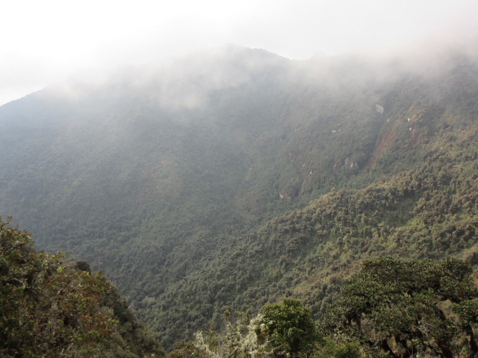
Our campsite, Phuyupatamarca (whose name translates very appropriately as ‘Cloud Level Town’) is known to deliver some of the best sunrise views in the entire Machu Picchu Sanctuary. It is also said to be the most impressive Inca site encountered along the trail so far. Unfortunately, it was late and getting dark when we arrived last night and ‘in the clouds’ this morning, but that made it even more atmospheric. 


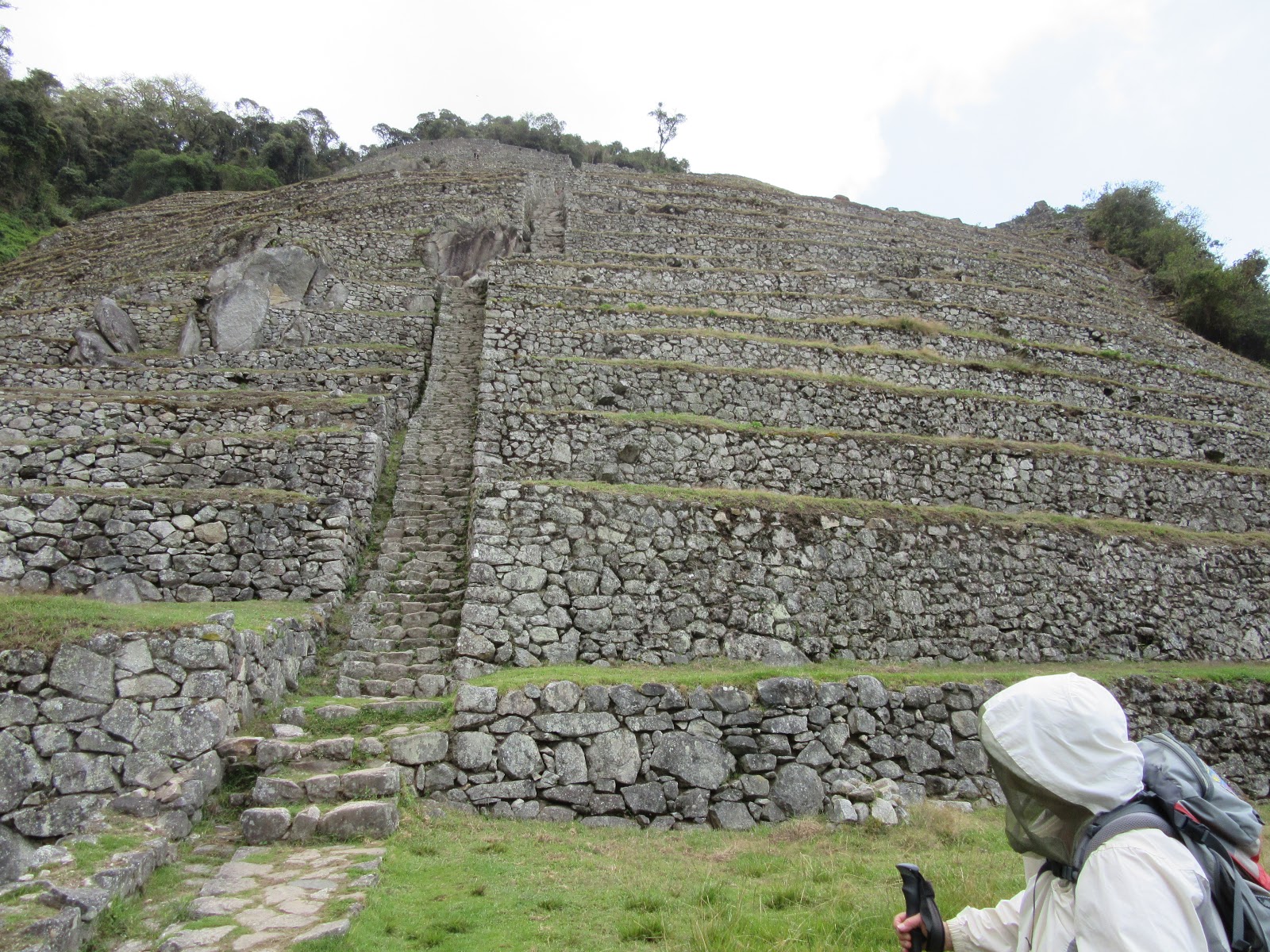
The site is thought to date from the 15th century. The ruins occupy a pyramid of seven terraces that hug the contours of a spur linked by a fine stairway. The long straight staircase descends between several tiers of buildings. To one side are six ‘Inca baths’ that were probably not used to wash in but rather used in conjunction with the ritual worship of water.
We set off at around 8:30am and continued our trek along a buttress, passing the ruins at Phuyupatamarca. From the lowest terrace of the ruins there was a flight of stairs leading downhill.
This was the most impressive set of steps on the entire Inca Trail. The Incas turned a 500m hillside into a staircase, etching each step out of the natural shape of the bedrock: one giant boulder had over 30 steps carved into it. The trail coiled down into dense cloud forest, one of the most delightful wooded sections on the trek.

Having stepped down the Inca staircase for around an hour we got our first glimpse of the old Treker’s Hotel, it’s tin roof visible amongst the trees. We carried on along the traditional Inca Trail route.


After another 1.5 hours, we got our first glimpse through the trees of the enormous site of Intipata that we were approaching. Intipata literally means ‘sunny slope’, and the name is particularly apt for this massed range of 48 uncovered terraces that seem to stretch on endlessly. There are three houses concealed in hollow terraces, but otherwise there are no plazas, ceremonial sites or fortifications to disturb the broad sweeping terraces, suggesting that the site was used exclusively as an agricultural outpost. However, given the broad panoramic views down into the valley to the site of Choquesuysuy and across the mountains to the lookout platform on top of Cerro Machu Picchu, the site probably had some sort of strategic importance as well. By using Intipata as mid-point, messages could have been transmitted from the valley floor all the way to Machu Picchu.
The path emerged on one of the upper terraces and we descended to the lowest terrace on an incredible stone staircase.


Machu Picchu is called ‘The Land of the Orchids’. There have been many species living for centuries in the Machu Picchu Historical Sanctuary, but the orchid is the queen of all plants and living creatures, with over 300 species and many colors found here, they are a beautiful thing to observe and smell.
The Orchid is the most evolved plant in the vegetal kingdom, carrying the DNA of many other plants, and that is the reason for its adaptability. Orchids have developed between 20 and 30 thousand species of the plant. Its’ growth is compared with that of humans and dolphins.

The size of the Orchids reveals their extraordinary adaptation to the environment, ranging between 1cm to 7m. Because the size and shape of the flowers are so varied many botanists can’t tell if some Orchids are really Orchids, with their strange and weird but colorful and beautiful shapes.
Garcilaso de la Vega, was one of the first Incan’s who saw the genetic importance and potential of orchids. He said that this flower should be used as a military ribbon by the troops, and they called it Wiñay Wayna (Forever young).
The 48 terraces at Intipata were cleared by Dr. Paul Fejos during a four-month period in 1940. Despite cutting and removing 40,000 square meters of jungle, he was convinced that there was still more to be uncovered. Although historians are anxious to try and reveal as much as possible, naturalists are concerned that insensitive clearing and blunt restoration techniques have damaged prime habitat favoured by a breed of very rare orchid. To preserve the habitat and protect the flower, there are frequent rumours that the site will be closed and left uncleared, and that the jungle will simply be allowed to reclaim the ancient stones.
From the lowest terrace of Intipata, the trail led to the last campsite before Machu Picchu and the old Trekkers’ Hotel. The hotel is now closed and has been allowed to fall into disrepair, but the campsite is very busy and when we arrived it was crowded with porters. We were met by a few of our porters and stopped here for lunch. Another outstanding, delicious meal, and our last camp meal on the trek. The rest of the porters had gone to the river to wash the tents and other gear. The porters would all be returning to Ollantaytambo today.

From lunch, a short 10-minute walk took us through the cloud forest to well-conserved ruins located just below the ridge. Julio C. Tello, one of the most important archaeologists of Peru, found the Wiñay Wayna species of orchid in the region, and decided to name this site Wiñay Wayna.
You have probably noticed me saying each of the sites we have visited along the Inca trail have been the most impressive as we get closer to Machu Picchu, and once again this was the most impressive site on the Inca Trail so far. Dating from the second half of the 15th century, the site shares characteristics with Intipata: both comprise a series of fine, curving terraces spread across a hillside and both were used to grow crops.  However, Wiñay Wayna is a much more significant and important site; the stonework here is very impressive and of a much higher quality than at Intipata.

This complex’s sweeping terraces lead round to a series of buildings with high quality masonry, a double-jam doorway and a curved structure that looks out over Mt. Veronica.  The finest examples of Inca stonework can be found in these buildings, which are constructed out of some of the largest and most perfectly fitted blocks along the Inca Trail. There are also lots of gables and exterior pegs used to secure thatched roofs. From this upper cluster a staircase descends to a second level, alongside a sequence of 10 stone baths, down which flows water from a spring that originates at Phuyupatamarca. The likelihood is that these were involved in the ritual worship of water and that the site had an important role as a ceremonial or religious centre.
From the last structure at the lowest level, there’s a trapezoidal window that frames a nearby waterfall, reinforcing the idea that the site was connected with the veneration of water.
We returned to our lunch spot and had one last visit to the toilet tent, said our thanks and goodbyes to Peter the cook and the other remaining porters, and then set off to Machu Picchu along the same trail the Incas once used.

From Wiñay Wayna it took about two hours to trek through dense cloud forest to reach Intipunku (sun gate). The trail undulates a little, then passes a couple of steep rock faces, climbing a total of about 150m.  At one point I asked Carlos if there many more steep climbs left, and he said the ‘gringo killer’ was coming up at the end. When we got there, Carlos took our poles and we had to use both our hands and our feet to climb the 14 very steep steps to get to Intipunku. This was the remains of a watchtower and fortress of the sacred city that commanded superb views south back to Intipata, Wiñay Wayna, Phuyupatamarca, and Choquesuysuy.

Intipunka is now also the name of the final section of the Incan Trail between the Sun Gate complex and the city of Machu Picchu. Note that many of the people in our picture above didn’t get there by walking the Inca Trail from Km 82 like we did, but rather by hiking about 1.6 km and climbing up 260m from Machu Picchu.
Intipunku is one of the most important archeological constructions around the Machu Picchu site. It was once the main entrance to Machu Picchu, being the primary approach from the then capitol city of Cusco. The gate likely would have been protected by Incan military. It was believed that the steps were a control gate for those who enter and exited the Sanctuary.  
 Because of its location on a ridge southeast of Machu Picchu, the rising sun would pass through the Sun Gate each year on the summer solstice. It is a wide archaeological site with windows and gates that are held up by terraces. You are also able to see the sun rise over the mountains by Machu Picchu from here, which is why some of the people at our campsite last night got up and left at 3:30am.
From Intipunka, the magnificent 15th Century Inca citadel of Machu Picchu unfolded at our feet, sheltered under Huayna Picchu.


After some time soaking in the glorious view, we walked down to the ruins to take a bus to the village of Machu Picchu, Aguas Calientes. The road made a series of switchbacks down the mountain to the village. It was very steep and narrow and took a good 30 minutes to make its way down.

We went to the main square in Aguas Calientes and Carlos took Sue Anne and Mike to their hotel while we waited.  I needed some pharmacy products and we tried to procure them while waiting, using sign language to communicate! I managed to get most of the items I was looking for.

Sue Anne, Mike, and Carlos re-appeared, and Carlos escorted us the restaurant he recommended we meet at later to have supper. He then pointed Russell and I in the direction of our hotel and went to his.
Our hotel was lovely, but quite a trek up a steep hill from the main square, and across a bridge. We still only had our camping duffle bags, so did some laundry and thankfully the room was well stocked with soap, shampoo and conditioner. It was nice to have a shower and get cleaned up a bit, but we still only had our hiking clothes and gear. Memories of the Camino.
The restaurant was very good, and it was nice to have a glass of wine and reminisce about our experiences on the trek. Sue Anne, Mike, Russell and I covered Carlos dinner.
We were to meet tomorrow morning at 7:30am to get the bus up to Machu Picchu for our tour of the Sanctuary, accompanied by our knowledgeable guide Carlos.
Russell and I had to climb back up the hill and over the bridge to our hotel after dinner.  Everyone else went down the hill to their lodging.
Day 4 Distance: 8km; Ascent: 150m; Descent: 1075 m; Elapsed time 7:30hr (8:30am to 4:00pm); Moving Time: 5hr.


Tuesday, 26 December 2017

Tuesday – Oct 3, 2017 Llulluchapampa to Phuyupatamarca
Inca Trail Day 3
It was another beautiful sunny day. We got up at 5am and this time I didn’t bring my tea into the tent, but left it outside under the fly beside our bowls of water. Everyone was excited about the challenges the day of trekking would bring. We were all hustling to get going after breakfast when Russell suddenly took off in the direction of the washroom. Peter, our cook, was distributing the water and snacks, so I filled up Russell’s water bottles and got his snack for him. Snack today was a passion fruit and dried banana chips. We were all ready to go at 6am perfectly according to plan. That’s when everyone else seemed to realize that Russell had disappeared. Carlos was asking one of the porters if he knew where Russell was, and the porter pointed in the direction of the toilet block.
After several minutes, Carlos gathered up Russell’s backpack and poles and we all took off to the toilets. Carlos didn’t say anything, but it was obvious that he was getting impatient to get going. It was going to be a very long day and hiking after dark wasn’t something any of us wanted to do on the Inca trail. Another ten minutes or so later, Russell finally joined us. He’d had to do some emergency laundry and the giant washing trough had come in handy for that. We set off at about 6:20am
The day began with a steady ascent up to Warmiwanusqa Pass (4,200m/13,692ft), which is more commonly called Dead Woman’s Pass. It isn’t known who the dead woman was or even if there was a dead woman at all. Many put the name down to the fact that the pass resembles a woman lying on her back as if dead (and the pass runs between her breasts).

We could make out the pass from the trail shortly after leaving our campsite, and the ascent looked deceptively simple. It reminded me a bit of climbing Masatiompom mountain to the col on Brandon Mountain on the Dingle Way in Ireland. Approaching it from a distance it looked like a rolling hill, but it was a hard climb and every time we turned around we were amazed at how high we had gotten in a short distance.
Thankfully we had already climbed 1,350 of the 1,710 meters to get up to the first pass, so we ‘only’ had 360 meters left to climb (in over slightly more than 2 km).


The path was parallel to the Quebrada river up to its source and then across the puna (grassland) and over a section of paved path, which was laid in 1998 to protect the mountain from erosion.


We stopped part way up and had a snack and caught our breath. I asked Carlos if many of the trekkers he’d guided had needed oxygen along the way. He had a tank in his backpack in case someone developed altitude sickness (AMS). He said he sometimes had trekkers ask him for oxygen when he knew they didn’t need it, and he would tell them so. Some had gone on to insist on him giving them some oxygen, so he’d ‘pretend’ to give them oxygen, and they all felt better just thinking they had gotten some. He said it does occasionally happen that a trekker develops a severe form of altitude sickness, and in that case porters would carry them by stretcher off the trail and get them transported to the hospital. Once, he had a man die in his tent during the night.  He had had a heart problem he hadn’t told anyone about.
As we rested we were passed by several groups of porters powering their way up. Most of them were fairly young looking, and it looked like many of them were exceeding the 20kg per pack max.
Russell and I got musing about the trek. This trek was different from all the other pilgrimages we have gone on in the sense that virtually all our attention was focused on where we were going to put our feet at every given moment. Popular psychology today tells us that being mindful, being present, being conscious of life as you live it is the only way to live life to the fullest. This trek exacted mindfulness.
Almost at the top.
What a feeling of accomplishment at the top. And relief that we survived the altitude. We took another well-deserved break (along with a few dozen porters) and enjoyed the rewarding views afforded by the ascent we’d just conquered! Altogether, including numerous breaks, it took us about 3.5 hours to get over the pass from our campsite this morning. Thank heavens we did it early, it was already 25ºC at 10am.


Our next challenge was the descent to the Pacaymayo River that lay ahead. From the broad saddle that marks the pass, the path descends steeply and swiftly into the neighbouring valley, plummeting 850 meters in just over 1.5 kilometers.


We ran into other trekkers today, something we hadn’t done on the first two days. One of the joys of the Camino to Santiago was meeting fellow pilgrims, either on the road or when sharing meals. You fall naturally into fellowship, sharing stories and getting to know a small but profound slice of one another’s lives. Since it took your full attention to navigate most of the Inca trail, any conversation with other trekkers was mainly limited to break times, and during the meals shared with Carlos, Mike and Sue-Anne. But we still felt an intense bond with the other trekkers we met along the way, just by sharing in such an awe-inspiring landscape and incredible journey. I noticed that most of the other trekkers we met, both on and off the trail, were much younger than us. I found a lot of hope in the fact that, so many young people are interested in making such a journey.
I had managed to be way out in front of everyone on the last part of that descent. On the steep ascents on this trek, I seemed to always be bringing up the rear. I have been suffering a bit with shortness of breath for the last few years and I got some Ventolin from my doctor before we left. I went for a breathing test after I got back home, and it turns out that I have asthma which is apparently causing a condition where my lungs don’t expel the air I breath in properly (ie, they trap carbon dioxide).  At least I have a more valid excuse than being out of shape for my shortness of breath, especially on the steep climbs at high altitudes. The Ventolin was helping.
At the bottom of that dizzying descent was Pacamayo campsite, a vast, sprawling campsite set amidst some scrubby trees, adjacent to the Pacamayo river. According to our guide, it is popular with large tour groups, and although the facilities are good here, with two toilet blocks, it is often noisy and crowded.
It was very noisy and busy when I arrived at the campsite.  This time I made sure to follow the first sign I saw to the toilet blocks, to avoid any unnecessary subsequent climbing. Back on the trail through the campsite, I was soon greeted by one of our porters, who invited me to sit.  The rest of the group soon arrived.  Mike and Russell (and Carlos as well, I suspect) had been having a few issues with their knees.  The porter offered us tea and a ham sandwich, to tide us over until lunch. It was the best sandwich I’ve ever had.
From the Pacamayo camp the path climbed very steeply up a series of steps, crossing two bridged sections over precipitous drops where the original trail has crumbled away, to the Inca ruins of Runcu Raccay. We had magnificent views over the valley below while climbing. The 500-meter ascent on this section included 170 steps (I think that’s what Carlos said) from the trail to get to the ruins, but it was well worth the extra climb.

The climb on this section of the trail (500 m) was much easier than today’s portion of the climb up to the first pass (360 m) for one obvious reason.  The altitude was much higher on the first climb.  Runcu Raccay was at an altitude of 3850 meters, which is close to the altitude of our camp this morning, compared to an altitude of 4200 meters at the first pass. From Runcu Raccay we had an outstanding view back to Dead Woman’s Pass.
IRuncu Raccay is perched precariously above a high chasm on a large terrace with a superlative view across the valley. It is thought to have been a tambo for passing travelers. A tambo (Quechuan "inn") was an Inca structure built for administrative and military purposes. Found along Incan roads, tambos typically contained supplies and served as lodging for itinerant state personnel. The popular theory is that the site is a transitional building, taking travelers from the purely practical buildings in the Cusichaca Valley to the far more elaborate, significant structures closer to Machu Picchu. Its location would have been very deliberate though, with the Incas keen that people passing this way had the chance to venerate their surroundings.
Carlos explained the religious significance of the site to us, evident from the circular walls, and altars inside, as well as its significance as an astronomical observatory.

The second pass was about an hour up, beyond a series of false summits and at the top of a series of steep staircases. Just before the real pass, the path winds between two lakes. The ground around the lakes is boggy and trekkers are told to stay strictly on the gravel path so as not to damage the fragile eco-system.
The second pass is another broad saddle and offers exceptional views of the Pumasillo and Vilcabamba range. Below it the path again falls away steeply into the adjoining Aobamba Valley.


Having descended through a short tunnel the trail begins a series of tight switchbacks, dropping height quickly until it reaches a small viewpoint atop a promontory.  Beyond here the descent is more gradual and the path curls and coils across the slopes. To the right of the pass lies a large, algae-covered lake.

Ahead of us, the dramatically situated ruins of Sayac Marca were visible straddling a rocky spur high above the cloud forest. The ruins are protected on three sides by sheer cliffs that fall away to the jungle far below. No one is sure what these superb ruins were originally used for.

Around a hairpin bend and sitting in the shadow of Sayac Marca was a small set of ruins at Concha Marca. Tucked in a little valley and perched atop a series of tall, rounded terraces, these ruins were only uncovered in the early 1980’s.

Beyond those ruins lay a stretch of very attractive trail. The path skirts a series of precipices on stone slabs, most of which are of Inca origin, and contours through some very beautiful cloud forest.

We stopped for lunch at Chaquicocha, where some trekkers were setting up camp for the night. It was around 3:30pm, which made it a late lunch, but we left late and we may have been going a bit slow. We had had a sandwich around noon at Pacamayo, and I wasn’t feeling particularly hungry. I was feeling exhausted at this point and was thinking it was too bad we weren’t staying there overnight. I asked Carlos if he ever had anyone crying and pleading to stop here for the day. He said, ‘Oh yes’, and proceeded to tell us some stories about that. It was another superb meal, and the opportunity to rest for close to an hour was certainly appreciated.
After lunch, the trail snaked steeply uphill, past two viewpoints. Then a section of intricately laid Inca paving lead down to an Inca tunnel. This 16m long corridor exploits a fault in the seemly sheer cliff that blocked the way ahead.
Emerging from the tunnel the path climbs again to the third pass. The walk along the ridge offered a leisurely respite from the day’s challenging ascents and long descents as well as incredible views of the beautiful Aobamba Valley below. We continued along the ridge through amazing landscapes and views of Mt. Salkantay on the western side, as well as Mt. Pumasillo silhouetted on the horizon to the north. We followed the flag-stoned trail until we arrived at our campsite at Phuyupatamarca, also known as “the village over the clouds.” We got there around 5:10pm, so maybe we made-up a bit for the late start.


There were other groups camping there, but they were separated from us physically, not visually. There were also toilet blocks, but I was hooked on the toilet tent by this point.

We were to meet for appetizers at 5:30 and dinner at 6pm. This was the day we were going to work out the tips for the porters. We had guidelines on how much we should tip if our group size was eight. We were only four, but we all agreed that the porters should still get the recommended tip, because they had worked so hard and looked after us so well.  If it hadn’t been for them, we wouldn’t have been able to make the journey.
Russell washed his face and then left me with the two bowls of water. I was so tired and sore from the day’s trek that it took me ages to have my bath.  By the time I made it to the dining tent, the others had worked everything out about the tips and it was dinner time. I still managed to taste some of the appetizer that evening, which was delicious, and the soup was so good that that was all Carlos had for supper. It was raining a bit that evening and very foggy. It also wasn’t easy to get between tents (dining, sleeping, toilet) because they were on different rocks with steep drops between them, and it was slippery from the rain.
We left our poles outside the tent when we went to bed, but the porters picked them up and put them in the dining tent overnight, which was much appreciated.
I was awakened at around 3am by a lot of activity around the campsite. I didn’t know what was happening, and was concerned that Mike and Sue-Anne were having a problem. It turned out that some of the other groups of campers had gotten up that early to arrive at the Sun Gate at sunrise. I asked Carlos about that later, it sounded like it might be very spiritual to arrive there at sunrise. He said there are a few problems with that. For one, you would miss the beautiful scenery on the last part of the trail, walking along in the dark with a bunch of bobbing headlamps; you would be tired when you arrived at Machu Picchu, from the lack of sleep; and, it is often very foggy early in the morning and you don’t even see the sunrise.
A bit later, I had to go to the bathroom.  I decided it would be too dangerous with all the slippery rocks to try to get to the toilet tent in the dark, fog and rain, and just went outside the tent.
We didn’t have too far to walk tomorrow, so wake-up wasn’t until 7am.
Day 3 Distance: 14km; Ascent: 1030m; Descent: 1080 m; Elapsed time 10.5hr (6:20am to 5:10pm); Moving Time: 7hr.